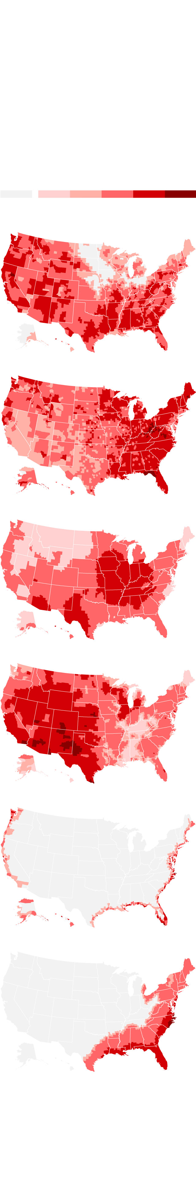
Projected risk of exposure to climate hazards in the United States
An analysis by Four Twenty Seven, a firm that analyzes climate risk data, evaluated indicators for climate hazards and combined them with the projected population in 2040. The resulting scores reflect each county's climate risk exposure relative to a global distribution of climate hazard scores.
Projected risk of exposure to various climate hazards for 2030-2040
None
Very low
Low
Medium
High
Red flag
Wildfires
Floods
Heat stress
Water stress
Sea-level rise
Tropical
cyclones*
*Map shows exposure to past tropical cyclones because global projection data are unavailable due to uncertainty in the current projections.
Notes: Climate hazard estimates are based on expected climate change impacts under a high greenhouse gas emissions scenario. The data also does not account for the range of possible warming that could occur under this scenario or humans’ ability to adapt to future conditions.
Source: Four Twenty Seven
Graphic: Renée Rigdon, CNN
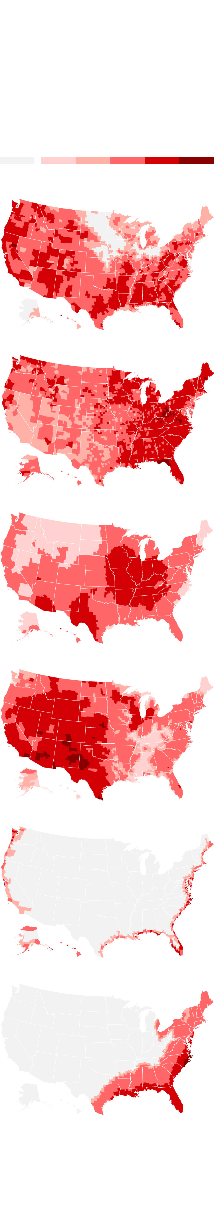
Projected risk of exposure to climate hazards in the United States
An analysis by Four Twenty Seven, a firm that analyzes climate risk data, evaluated indicators for climate hazards and combined them with the projected population in 2040. The resulting scores reflect each county's climate risk exposure relative to a global distribution of climate hazard scores.
Projected risk of exposure to various climate hazards for 2030-2040
None
Very low
Low
Medium
High
Red flag
Wildfires
Floods
Heat stress
Water stress
Sea-level rise
Tropical cyclones*
*Map shows exposure to past tropical cyclones because global projection data are unavailable due to uncertainty in the current projections.
Notes: Climate hazard estimates are based on expected climate change impacts under a high greenhouse gas emissions scenario. The data also does not account for the range of possible warming that could occur under this scenario or humans’ ability to adapt to future conditions.
Source: Four Twenty Seven
Graphic: Renée Rigdon, CNN

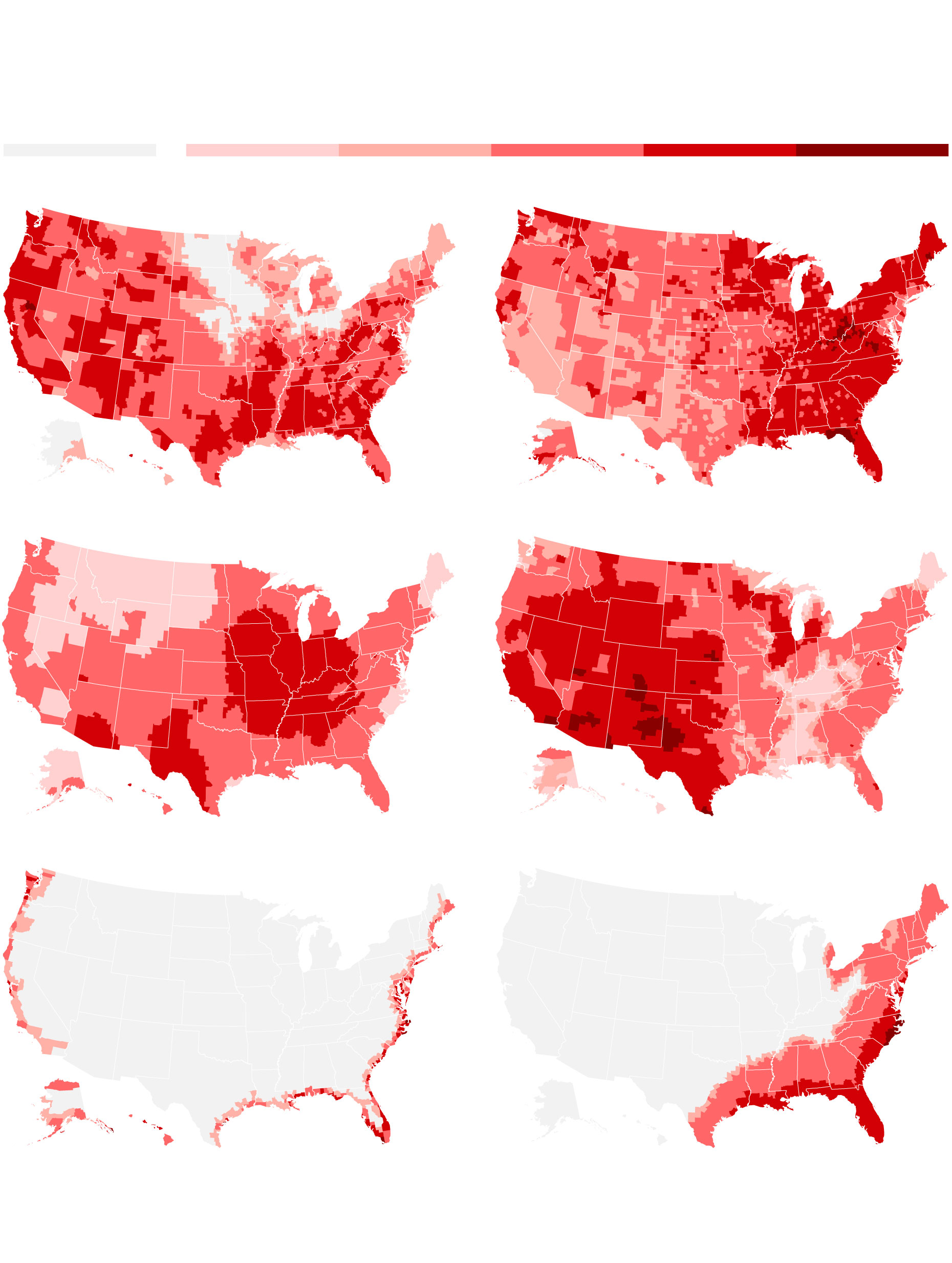
Projected risk of exposure to climate hazards in the United States
An analysis by Four Twenty Seven, a firm that analyzes climate risk data, evaluated indicators for climate hazards and combined them with the projected population in 2040. The resulting scores reflect each county's climate risk exposure relative to a global distribution of climate hazard scores.
Projected risk of exposure to various climate hazards for 2030-2040
None
Very low
Low
High
Red flag
Medium
Wildfires
Floods
Heat stress
Water stress
Sea-level rise
Tropical cyclones*
*Map shows exposure to past tropical cyclones because global projection data are unavailable due to uncertainty in the current projections.
Notes: Climate hazard estimates are based on expected climate change impacts under a high greenhouse gas emissions scenario. The data also does not account for the range of possible warming that could occur under this scenario or humans’ ability to adapt to future conditions.
Source: Four Twenty Seven
Graphic: Renée Rigdon, CNN
Projected risk of exposure to climate hazards in the United States
An analysis by Four Twenty Seven, a firm that analyzes climate risk data, evaluated indicators for climate hazards and combined them with the projected population in 2040. The resulting scores reflect each county's climate risk exposure relative to a global distribution of climate hazard scores.
Projected risk of exposure to various climate hazards for 2030-2040
None
Very low
Low
Red flag
Medium
High
Floods
Wildfires
Heat stress
Water stress
Sea-level rise
Tropical cyclones*
*Map shows exposure to past tropical cyclones because global projection data are unavailable due to uncertainty in the current projections.
Notes: Climate hazard estimates are based on expected climate change impacts under a high greenhouse gas emissions scenario. The data also does not account for the range of possible warming that could occur under this scenario or humans’ ability to adapt to future conditions.
Source: Four Twenty Seven
Graphic: Renée Rigdon, CNN
