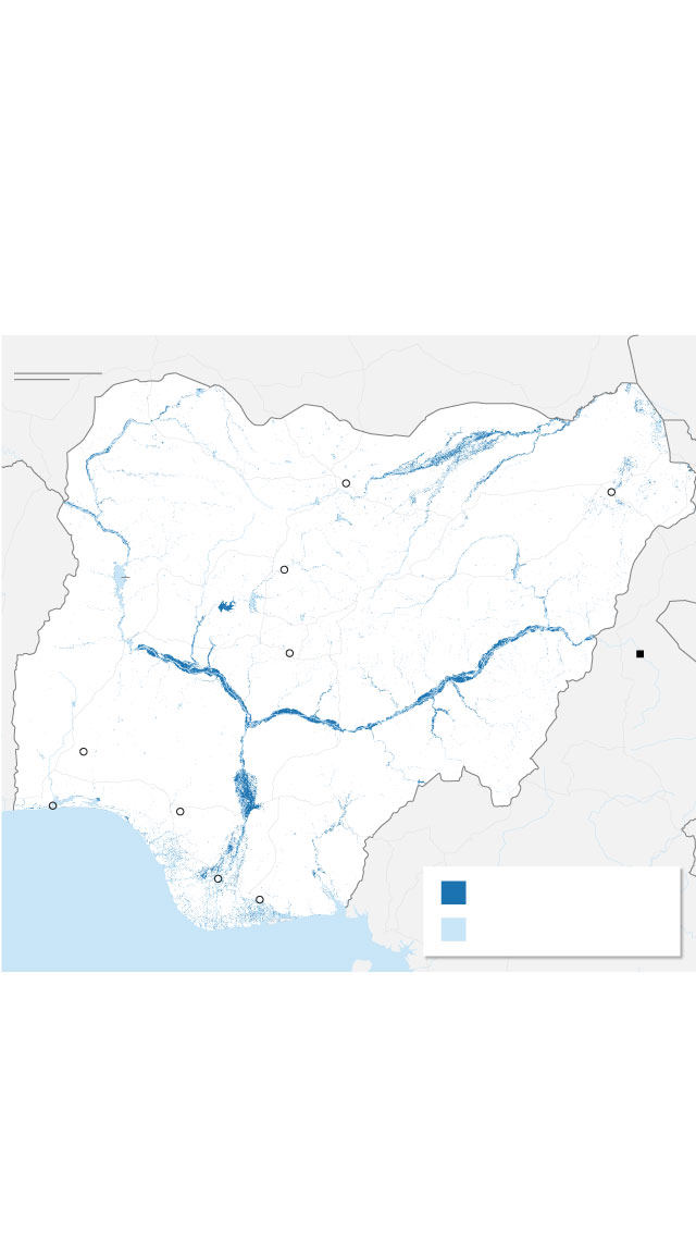
Flooding along Nigeria’s major rivers has affected millions
Catastrophic flooding along Nigeria’s major rivers has displaced more than 1.5 million people and has killed more than 600, according to the Nigerian government and humanitarian ministry. The flooding has been attributed to above-average rainfall and the overflowing of Lagdo dam in Cameroon.
100 miles
NIGER
100 km
Yobe R.
Sokoto R.
Kano
Bunga R.
Maiduguri
BENIN
Kaduna
Kainji
Reservoir
NIGERIA
Niger R.
Abuja
Lagdo
dam
Benue R.
Niger R.
Ibadan
Lagos
CAMEROON
Benin
City
Odi
Flooded areas
Port
Harcourt
Gulf of Guinea
Permanent water
Note: Data is based on satellite observations of water across Nigeria between October 1-19. Flooded areas are where water was present in multiple satellite observations during that period. The flood extent does not include main rivers or water bodies that are present in at least 30% of historical satellite observations.
Source: Cloud to Street
Graphic: Renée Rigdon and Krystina Shveda, CNN
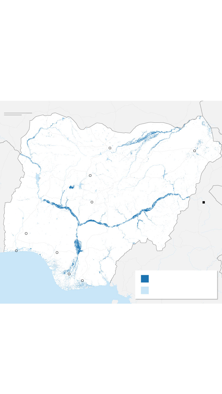
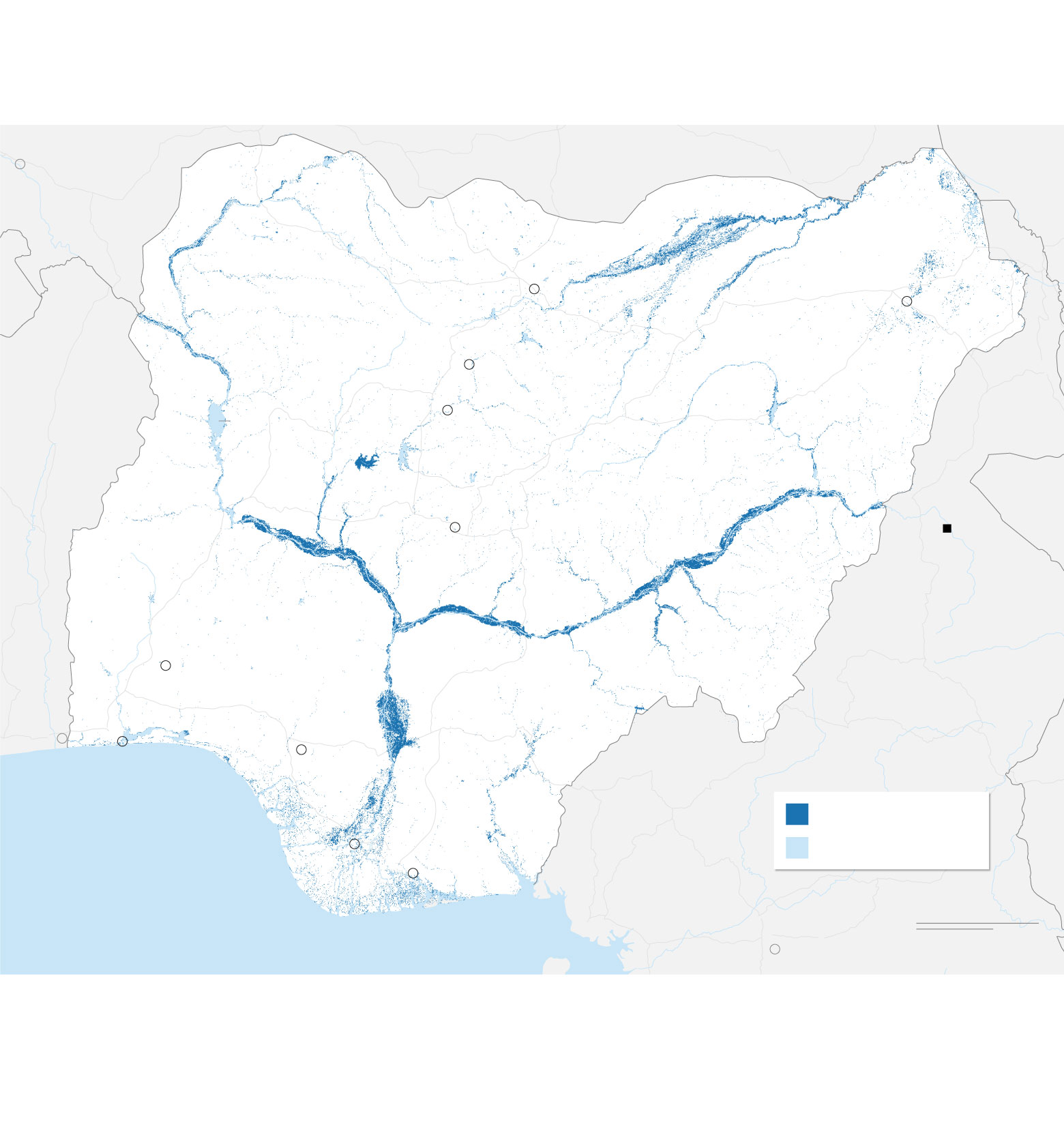
Flooding along Nigeria’s major rivers has affected millions
Catastrophic flooding along Nigeria’s major rivers has displaced more than 1.5 million people and has killed more than 600, according to the Nigerian government and humanitarian ministry. The flooding has been attributed to above-average rainfall and the overflowing of Lagdo dam in Cameroon.
NIGER
CHAD
Niamey
Yobe R.
Sokoto R.
Kano
Maiduguri
Bunga R.
Zaria
Kaduna
BENIN
Kainji
Reservoir
NIGERIA
Niger R.
Abuja
Lagdo
dam
Benue R.
Niger R.
Ibadan
CAMEROON
Porto-
Novo
Benin
City
Lagos
Flooded areas
Odi
Permanent water
Port Harcourt
Gulf of Guinea
100 miles
Yaounde
100 km
Note: Data is based on satellite observations of water across Nigeria between October 1-19. Flooded areas are where water was present in multiple satellite observations during that period. The flood extent does not include main rivers or water bodies that are present in at least 30% of historical satellite observations.
Source: Cloud to Street
Graphic: Renée Rigdon and Krystina Shveda, CNN

CNN GRAPHICS STYLE GUIDE • Map styles
Labeling hierarchy 1
Labeling hierarchy 2
Use for maps with countries as the
primary geography
Use for maps with states or provinces
as the primary geography
PRIMARY country
PRIMARY state
SECONDARY country
SECONDARY state
COUNTY NAME
STATE/PROVINCE NAME
country name (IF NEEDED)
General styles
Sample text
A block of sample text will go in this space, describing what happened at a specific place, perhaps at a specific date.
Highlight city
Secondary/tertiary land
(primary land is white unless
water is white)
City
City
Capital city
Capital city
Parks/forests
Site/feature
Site/feature
Highway symbols
6
50
101
2
30
117
5
95
275
International boundaries
Numbered locations
8
1
2
3
4
5
6
7
9
Disputed boundaries
Rivers
DETAIL
NORTH
Roads

Legend title
Sample text
A block of sample text will go in this space, describing what happened at a specific place, perhaps at a specific date.
100,000
50,000
25,000
A23
A230
5,000
Legend title
Label
Label
Label