La región disputada de Cachemira
El conflicto de Cachemira es una disputa territorial entre la India y Pakistán, que también involucra a China. Cada país controla y reclama diferentes partes de la región desde la partición de la India británica, en 1947.
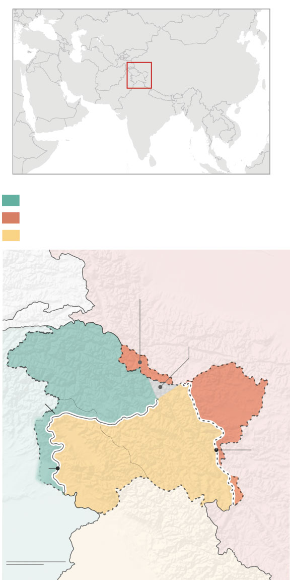
Administrado por Pakistán
Administrado por China
Administrado por la India
Territorio cedido a China por Pakistán en 1963
TAYIKISTÁN
CHINA
AFG.
Glaciar de Siachen
Gilgit-
Baltistan
Azad
Jammu
y
Cachemira
Aksai
Chin
Ladakh
Jammu y
Cachemira
Línea
de Control
Actual
(LAC)
Línea de
Control
(LOC)
PAKISTÁN
INDIA
100 millas
100 km
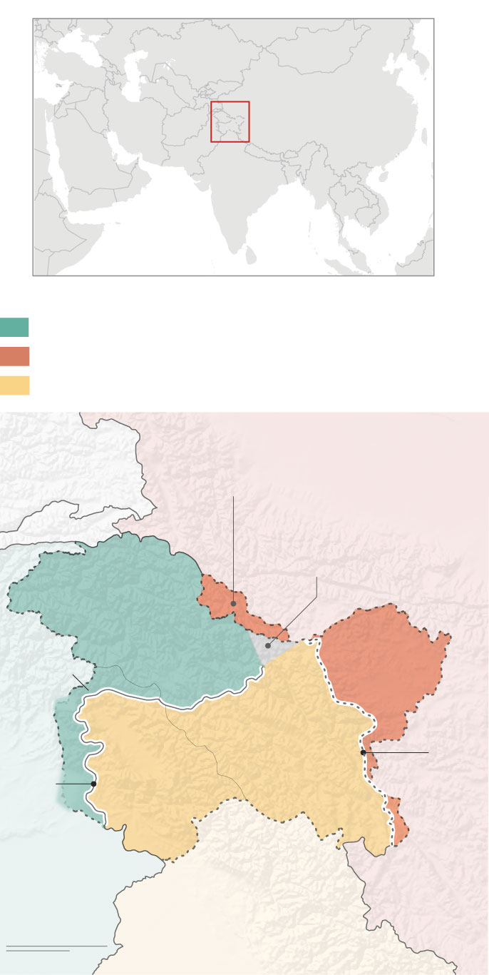
Administrado por Pakistán
Administrado por China
Administrado por la India
Territorio cedido a China por Pakistán en 1963
TAYIKISTÁN
CHINA
AFG.
Glaciar de Siachen
Gilgit-
Baltistan
Azad
Jammu
y
Cachemira
Aksai
Chin
Ladakh
Jammu y
Cachemira
Línea
de Control
Actual
(LAC)
Línea
de
Control
(LOC)
PAKISTÁN
INDIA
100 millas
100 km
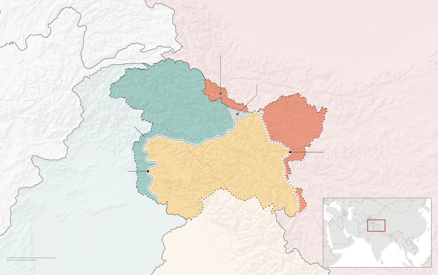
TAYIKISTÁN
Territorio cedido a China por Pakistán en 1963
CHINA
Glaciar de Siachen
AFGANISTÁN
Gilgit-Baltistan
Administrado
por Pakistán
Azad Jammu
y Cachemira
Administrado
por China
Aksai Chin
Línea de
Control Actual
(LAC)
Administrado por la India
Línea de Control
(LOC)
Ladakh
Jammu
y Cachemira
PAKISTÁN
INDIA
100 millas
100 km

CNN GRAPHICS STYLE GUIDE • Map styles
Labeling hierarchy 1
Labeling hierarchy 2
Use for maps with countries as the
primary geography
Use for maps with states or provinces
as the primary geography
PRIMARY country
PRIMARY state
SECONDARY country
SECONDARY state
COUNTY NAME
STATE/PROVINCE NAME
country name (IF NEEDED)
General styles
Sample text
A block of sample text will go in this space, describing what happened at a specific place, perhaps at a specific date.
Highlight city
Secondary/tertiary land
(primary land is white unless
water is white)
City
City
Capital city
Capital city
Parks/forests
Site/feature
Site/feature
Water bodies
Highway symbols
50
6
101
2
30
117
8
275
95
5
International boundaries
Numbered locations
8
1
2
3
4
5
6
7
9
Disputed boundaries
Rivers
xx miles
DETAIL
NORTH
Roads
xx km
LAND FEATURE (PARK, MTNS, LANDMARK)
Water body
River Name
River Name